The only thing I would add is that, for anybody that uses the \textwidth variable, it still refers to the width of the page, and not the width of the column, so use \columnwidth instead.
Equation of a Line

        /// <summary>
        /// Calculate the distance between two geocodes. Defaults to using Miles.
        /// </summary>
        public static double CalcDistance(double lat1, double lng1, double lat2, double lng2)
        {
            return CalcDistance(lat1, lng1, lat2, lng2, GeoCodeCalcMeasurement.Miles);
        }
        /// <summary>
        /// Calculate the distance between two geocodes.
        /// </summary>
        public static double CalcDistance(double lat1, double lng1, double lat2, double lng2, GeoCodeCalcMeasurement m)
        {
            double radius = GeoCodeCalc.EarthRadiusInMiles;
            if (m == GeoCodeCalcMeasurement.Kilometers) { radius = GeoCodeCalc.EarthRadiusInKilometers; }
            return radius * 2 * Math.Asin(Math.Min(1, Math.Sqrt((Math.Pow(Math.Sin((DiffRadian(lat1, lat2)) / 2.0), 2.0) + Math.Cos(ToRadian(lat1)) * Math.Cos(ToRadian(lat2)) * Math.Pow(Math.Sin((DiffRadian(lng1, lng2)) / 2.0), 2.0)))));
        }
        PointsOfInterest m_oMarkers = new PointsOfInterest();

        void cbMeasur!  e_Checked(object sender, RoutedEvent!  Args e)< br />        {
            Map1.Cursor = Cursors.Hand;
            m_oMarkers.Clear();
        }
        void cbMeasure_Unchecked(object sender, RoutedEventArgs e)
        {
            Map1.Cursor = Cursors.Arrow;
            if ( m_oMarkers.Count > 1 )
                AddLine(m_oMarkers,.5);
        }
        void Map1_MouseClick(object sender, MapMouseEventArgs e)
        {
            var oLocation = Map1.ViewportPointToLocation(e.ViewportPoint);

            PointOfInterest oPOI = null;
            if (cbMeasure.IsChecked == true)
            {
                oPOI = new Marker() { Loc = oLocation };
                m_oMarkers.Add(oPOI);
            }
            else
            {
        !          oPOI = new PointOfInterest()!   { Loc =  oLocation };
                m_oList.Add(oPOI);
            }

            RenderPoint(oPOI);

            if (cbDraw.IsChecked == true)
                try
                {
                    double dRadius = double.Parse(txtRadius.Text);
                    AddCircle(oLocation, dRadius, .5);
                }
                catch( Exception ex)
                {
                    MessageBox.Show(ex.Message);
                }
        }
       double DistanceInMiles(LocationCollection oLocs)
        {
            double dDistance = 0.0;
            for (int i = 0; i < oLocs.Count() - 1; i++)
                dDistance += DistanceInMiles(oLocs[i], oLocs[i + 1]);

      !        return dDistance;
       !   }

        double DistanceInMiles(Location Loc1, Location Loc2)
        {
            double dMiles = GeoCodeCalc.CalcDistance(Loc1.Latitude, Loc1.Longitude, Loc2.Latitude, Loc2.Longitude);
            return dMiles;
        }

        LocationCollection RenderLine(List<PointOfInterest> oList)
        {

            var oPOIs = (from oPOI in oList
                         where oPOI is Marker
                         select oPOI).ToList<PointOfInterest>();

            var oLocs = new LocationCollection();
            foreach (var oPOI in oPOIs)
                oLocs.Add(oPOI.Loc);

            return oLocs;
        !  }


        void AddLine(List<PointOfInterest> oList, double dOpacity)
        {
            MapPolyline polyline = new MapPolyline();
            polyline.Stroke = new SolidColorBrush(Colors.Red);
            polyline.StrokeThickness = 1;
            polyline.Opacity = dOpacity;

            //this works in miles
            LocationCollection oLocs = RenderLine(oList);
            polyline.Locations = oLocs;
            Map1.AddChild(polyline);

            double dDist = DistanceInMiles(oLocs);

            ToolTipService.SetToolTip(polyline, string.Format("{0:0.0} mi \n {1:0.00} yd", dDist, dDist * 5280.0 / 3.0));
        }
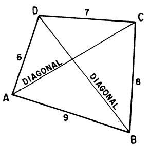 how to measure the perimeter of a quadrilateral. The perimeter of any quadrilateral, or any shape with four sides for that matter, is measured by adding the lengths of its sides. Hence, the quadrilateral on the ri! ght has a perimeter of 30 which is computed by adding the measure of its sides - 6 + 9 + 7 + 8.
